File:-IDAHO-L-0011- Teton Dam Flood - Newdale (5811753523).jpg
Size of this preview: 800 × 541 pixels. Other resolutions: 320 × 217 pixels | 640 × 433 pixels | 1,024 × 693 pixels | 1,280 × 866 pixels | 2,657 × 1,798 pixels.
Original file (2,657 × 1,798 pixels, file size: 510 KB, MIME type: image/jpeg)
Summary
| Description |
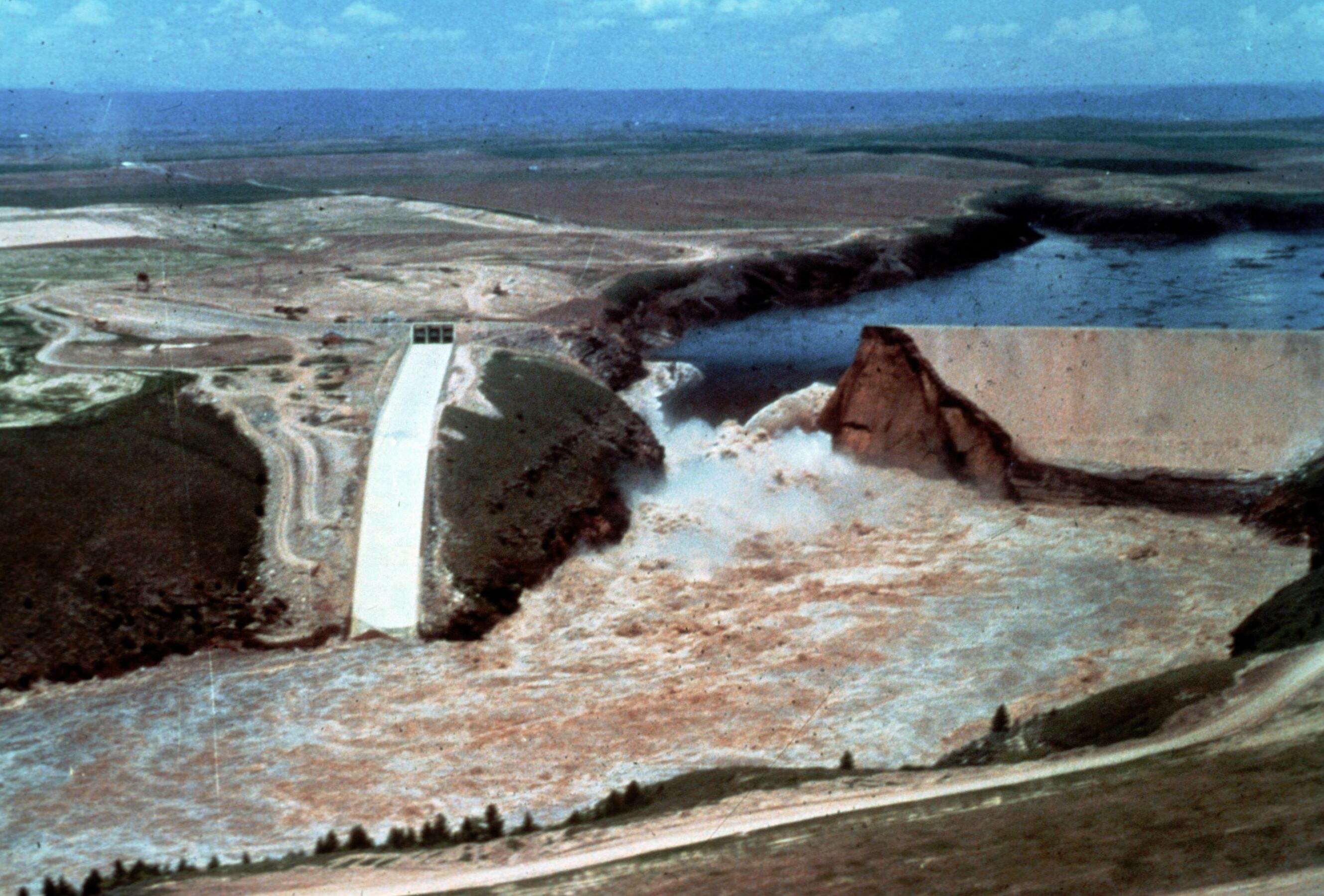
Image Title: Teton Dam Flood - Newdale Date: June 5, 1976 Place: Teton River, Newdale, Idaho Description/Caption: Progressive stages of break in the Dam. Statistics of interest: 80 billion gallons (220,000 acre feet) of water released. Floodwaters' path was seven miles wide in some places (average depth 8-10 feet). 100,000 acres of farmland stripped of topsoil; 13,000 head of livestock killed; 4000 homes, 50 businesses, 3500 farm buildings destroyed. Medium: color transparency Photographer/Maker: Bureau of Reclamation Cite as: ID-L-0011, WaterArchives.org Restrictions: There are no known U.S. copyright restrictions on this image. While the digital image is freely available, it is requested that <a href="http://www.waterarchives.org" target="browser" rel="nofollow">www.waterarchives.org</a> be credited as its source. For higher quality reproductions of the original physical version contact <a href="http://www.waterarchives.org" target="browser" rel="nofollow">www.waterarchives.org</a>, restrictions may apply. |
| Date | |
| Source | [IDAHO-L-0011] Teton Dam Flood - Newdale |
| Author | WaterArchives.org from Las Cruces, New Mexico, United States |
| Camera location | | View this and other nearby images on: OpenStreetMap |
|---|
Licensing
This file is licensed under the Creative Commons Attribution-Share Alike 2.0 Generic license.
- You are free:
- to share – to copy, distribute and transmit the work
- to remix – to adapt the work
- Under the following conditions:
- attribution – You must give appropriate credit, provide a link to the license, and indicate if changes were made. You may do so in any reasonable manner, but not in any way that suggests the licensor endorses you or your use.
- share alike – If you remix, transform, or build upon the material, you must distribute your contributions under the same or compatible license as the original.
| This image was originally posted to Flickr by waterarchives at https://flickr.com/photos/23487245@N08/5811753523. It was reviewed on 15 June 2020 by FlickreviewR 2 and was confirmed to be licensed under the terms of the cc-by-sa-2.0. |
File history
Click on a date/time to view the file as it appeared at that time.
| Date/Time | Thumbnail | Dimensions | User | Comment | |
|---|---|---|---|---|---|
| current | 15:13, 4 April 2023 | | 2,657 × 1,798 (510 KB) | wikimediacommons>Rémih | Cropped 8 % horizontally, 7 % vertically using CropTool with precise mode. |
File usage
The following page uses this file:
.jpg)
.jpg)
.jpg¶ms=043.910113_N_-111.539983_E_globe:Earth_type:camera_source:Flickr_&language=en)
.jpg?oldid=2027339)