File:Capital Beltway Map Color.png

Everything About Fiction You Never Wanted to Know.

Capital_Beltway_Map_Color.png(562 × 487 pixels, file size: 66 KB, MIME type: image/png)

This file is from Wikimedia Commons and may be used by other projects. The description on its file description page there is shown below.

Summary

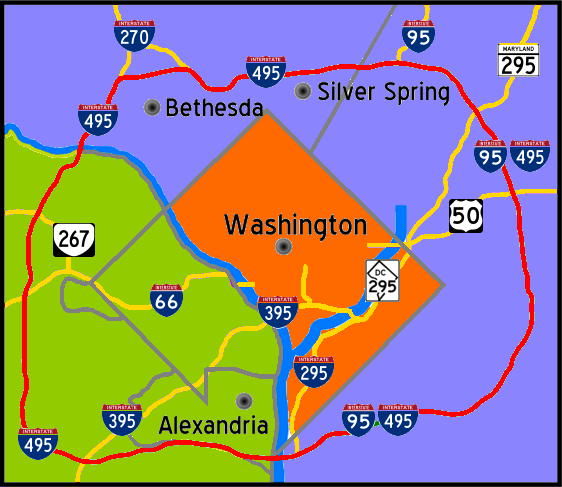
Description Interstate 495 in the state of Maryland and Commonwealth of Virgina in red surrounds the District of Columbia like a "belt", hence the name.
Date
Source Own work
Author Squiggygfm

Licensing

Public domain I, the copyright holder of this work, release this work into the public domain. This applies worldwide.
In some countries this may not be legally possible; if so:
I grant anyone the right to use this work for any purpose, without any conditions, unless such conditions are required by law.

Captions

Add a one-line explanation of what this file represents

Items portrayed in this file

depicts

26 April 2007

image/png

0e8576a2dc181f0e34d805017241da725415a8c4

67,584 byte

487 pixel

562 pixel

File history

Click on a date/time to view the file as it appeared at that time.

Date/TimeThumbnailDimensionsUserComment
current19:55, 26 April 2007Thumbnail for version as of 19:55, 26 April 2007562 × 487 (66 KB)wikimediacommons>Squiggyfm{{Information |Description= Interstate 495 in the state of Maryland and Commonwealth of Virgina in red surrounds the District of Columbia like a "belt", hence the name. |Source= |Date= April 26, 2007 |Author= Squiggygfm }}

The following page uses this file: